City guide · Block Island
Block Island: Manisses, New Shoreham, and a conserved island
Block Island sits in the Atlantic about 13 miles south of the Rhode Island mainland. Known to its Indigenous Manissean inhabitants as Manisses, it was settled by the English in 1661 and incorporated as New Shoreham in 1672. After a Victorian-era run as a steamship resort, the island is now notable for the large share of its land held in conservation.
The Manisseans and the island called Manisses
Long before Europeans arrived, the island was home to a Native community that called itself Manissean and called the island Manisses. The name is usually translated as "Island of the Little God," sometimes rendered as "Manitou's Little Island." The Manisseans were an Algonquian-speaking people closely related to the Narragansett and Niantic of the surrounding region, and archaeological evidence points to human occupation of the island reaching back thousands of years.
Far from being isolated, the Manissean community took part in the wider coastal economy. Excavated sites show evidence of organized settlement and of wampum production, the shell-bead manufacture that was central to trade and diplomacy across southern New England. Estimates of the pre-contact population vary, and exact figures should be treated with caution, but the island clearly supported a substantial year-round community.
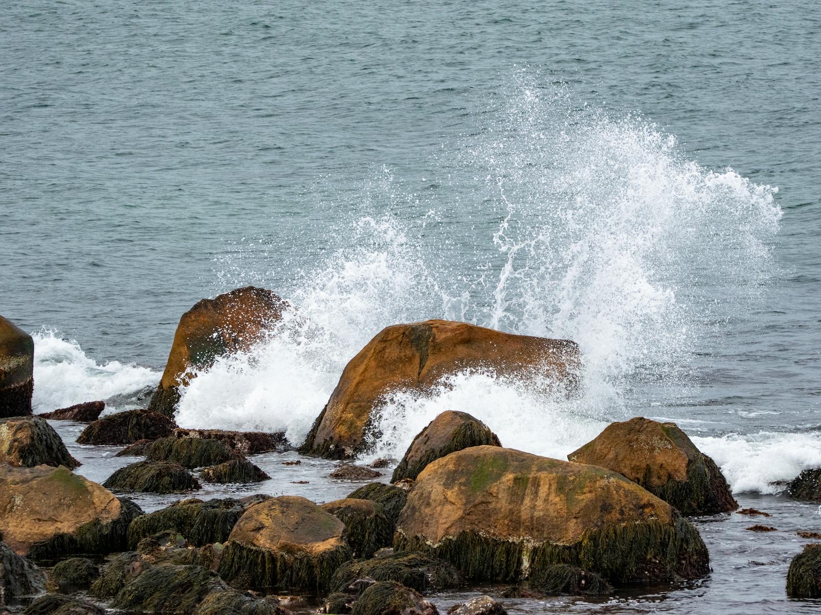
The cliffs on the island's southeastern shore are called Mohegan Bluffs. Local tradition holds that the name commemorates a confrontation in which Manissean defenders drove off a raiding party that had come from the mainland. The details of this account differ between sources and are not firmly documented, so it is best understood as a traditional story attached to the place rather than a settled historical record. What is well documented is that the bluffs rise roughly 150 feet above the beach and have long been one of the island's defining features.
Verrazzano, Adriaen Block, and English settlement
The first recorded European sighting came in 1524, when the Florentine navigator Giovanni da Verrazzano, sailing for France, noted an island off the coast. He is said to have named it Claudia, after Claude of France, but the name did not endure. In 1614 the Dutch navigator Adriaen Block charted these waters and the island came to carry his name, which it still bears.
English settlement followed several decades of upheaval. In 1636 the trader John Oldham was killed near the island, an event the Massachusetts Bay Colony used as justification for a punitive expedition under John Endecott that burned Manissean villages and cornfields. This raid was one of the events that led into the Pequot War of 1636 to 1637. These conflicts, and the colonial pressures that followed, sharply reduced the Native population over the rest of the century.
In 1661 a group of English settlers, organized largely from Massachusetts, purchased the island and began establishing farms. In 1672 the Rhode Island General Assembly incorporated the island as the town of New Shoreham, named for Shoreham in England. New Shoreham remains the island's official town name today, while Block Island is the more common usage.
A working island: farming, fishing, and the sea
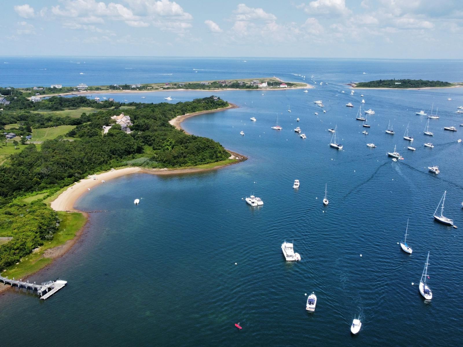
For most of its history Block Island was a farming and fishing community whose life was shaped by isolation. Surrounded by open water and difficult to reach, residents relied on the land, the surrounding fishing grounds, and a large interior body of water, the Great Salt Pond. In 1895 a permanent channel was cut to connect the Great Salt Pond to the ocean, creating what is now New Harbor and giving the island a protected anchorage. An earlier project at Old Harbor, where breakwaters were built around 1870 to 1873, had already improved access for larger vessels.
The waters around the island were dangerous, and shipwrecks were common. The federal government established life-saving stations to respond to wrecks; the New Shoreham station was built in 1874, with the islander and later congressman Nicholas Ball instrumental in its creation. These stations, forerunners of the modern Coast Guard, were a serious part of island life in an era of heavy coastal traffic.
Two lighthouses mark the island's ends. The North Light at Sandy Point, the granite structure standing today, was built in 1867; it was the latest in a series of lights on a site where earlier towers had been built beginning in 1829. At the southeastern corner, Southeast Light was completed in the mid-1870s and first lit in 1875, a brick Gothic Revival tower set above Mohegan Bluffs. As the bluffs eroded, the entire structure was moved back from the cliff edge in 1993 to save it. Southeast Light was later designated a National Historic Landmark.
The Victorian resort era
Improved harbor access and the spread of steamship service turned Block Island into a summer resort in the late nineteenth century. Through the 1870s, 1880s, and 1890s, large wooden hotels went up to receive visitors arriving by boat from the mainland and from southern New England ports. The island became a recognized seasonal destination, and the building boom of that period left it with an unusually large stock of Victorian-era hotel architecture.
Several of the great hotels date from this era. The Ocean View Hotel, built in 1872 by Nicholas Ball, was among the largest on the island before it was lost to fire in the twentieth century. The Spring House, which traces its origins to the early 1850s, and the National Hotel are among the surviving examples of the period's resort building.
The resort economy reshaped the island's character, layering a summer tourist trade on top of the older farming and fishing community. That seasonal pattern, a small year-round population swelling sharply in the warm months, has defined Block Island ever since.
Conservation and the island today
Block Island is notable today for how much of its land is protected. Conservation groups, including the locally founded Block Island Conservancy and The Nature Conservancy, have worked since the early 1970s to set aside open space, and close to half of the island, commonly cited in the range of about 40 to 45 percent, is now held in some form of conservation. The protected land supports plants and animals that have disappeared from much of southern New England.
In 1991 The Nature Conservancy named Block Island one of twelve "Last Great Places" in the Western Hemisphere, and the organization went on to establish a permanent presence on the island, managing thousands of acres of habitat and supporting research in and around the Great Salt Pond. The designation reflected both the island's ecological value and the local community's sustained support for conservation.
The island remains a working town as well as a destination. The year-round population is small, on the order of a little over a thousand residents on roughly ten square miles, and it rises substantially in summer. Most visitors arrive by ferry, with year-round service running from Point Judith on the Rhode Island mainland and additional seasonal routes from other New England and New York ports.
Places worth a stop
Where to go in New Shoreham
Mohegan Bluffs
The Block Island view that makes the ferry feel justified, but it should be planned around mobility, weather, and island transport.
Last checked
The Oar
A Block Island restaurant for visitors who need the ferry day to include a realistic New Harbor meal instead of only beach and bluffs.
Last checked
Sources
Reviewed source trail
- Block Island — Wikipedia — checked 2026-06-27
- Block Island — The Nature Conservancy in Rhode Island — checked 2026-06-27
- Block Island Southeast Light — Wikipedia — checked 2026-06-27
- Block Island North Light — Wikipedia — checked 2026-06-27
- Block Island (Manisses) — Dartmouth Occom Circle placeography — checked 2026-06-27
- Block Island History — Block Island Tourism Council — checked 2026-06-27
- New Shoreham Life-Saving Station — Block Island Ferry — checked 2026-06-27
- Pequot War — Britannica — checked 2026-06-27